


Paimpont

Evelyne Bouchereau
User

Length
21 km

Max alt
179 m

Uphill gradient
293 m
Km-Effort
25 km

Min alt
51 m

Downhill gradient
202 m
Boucle
No
Creation date :
2025-05-23 06:55:54.834
Updated on :
2025-05-24 11:25:46.297
5h48
Difficulty : Very easy

FREE GPS app for hiking
 SityTrail
IGN / Geographical institutes
SityTrail Plus
The world is yours!
About
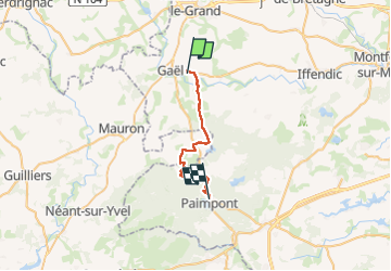
Trail Walking of 21 km to be discovered at Brittany, Ille-et-Vilaine, Gaël. This trail is proposed by Evelyne Bouchereau.
Positioning
Country:
France
Region :
Brittany
Department/Province :
Ille-et-Vilaine
Municipality :
Gaël
Location:
Unknown
Start:(Dec)
Start:(UTM)
559447 ; 5331018 (30U) N.
Comments