


Chantemelle

francoisecarlier
User
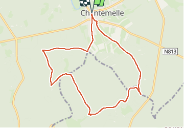

Length
9.1 km

Max alt
364 m

Uphill gradient
145 m
Km-Effort
11 km

Min alt
294 m

Downhill gradient
145 m
Boucle
Yes
Creation date :
2025-05-25 07:38:25.0
Updated on :
2025-08-10 18:38:09.323
2h30
Difficulty : Easy

FREE GPS app for hiking
 SityTrail
IGN / Geographical institutes
SityTrail Plus
The world is yours!
About
Trail Walking of 9.1 km to be discovered at Wallonia, Luxembourg, Étalle. This trail is proposed by francoisecarlier.
Positioning
Country:
Belgium
Region :
Wallonia
Department/Province :
Luxembourg
Municipality :
Étalle
Location:
Chantemelle
Start:(Dec)
Start:(UTM)
691393 ; 5503489 (31U) N.
Comments