


Bonnieux plage et au circuit Nord

jll7513
User

Length
4.5 km

Max alt
58 m

Uphill gradient
62 m
Km-Effort
5.3 km

Min alt
1 m

Downhill gradient
63 m
Boucle
Yes
Creation date :
2025-05-25 08:59:36.0
Updated on :
2025-05-27 15:38:13.842
1h12
Difficulty : Easy
0m
Difficulty : Very easy
33m
Difficulty : Easy

FREE GPS app for hiking
 SityTrail
IGN / Geographical institutes
SityTrail Plus
The world is yours!
About
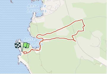
Trail Walking of 4.5 km to be discovered at Provence-Alpes-Côte d'Azur, Bouches-du-Rhône, Martigues. This trail is proposed by jll7513.
Description
Départ et retour de la plage en faisant demi tour au Nord de la voie de chemin de fer
Positioning
Country:
France
Region :
Provence-Alpes-Côte d'Azur
Department/Province :
Bouches-du-Rhône
Municipality :
Martigues
Location:
Unknown
Start:(Dec)
Start:(UTM)
663707 ; 4801086 (31T) N.
Comments