


Pointe de Puvat

Chabard
User

Length
12.5 km

Max alt
1883 m

Uphill gradient
935 m
Km-Effort
25 km

Min alt
989 m

Downhill gradient
938 m
Boucle
Yes
Creation date :
2025-05-25 08:02:51.0
Updated on :
2025-05-28 17:24:59.23
4h38
Difficulty : Difficult

FREE GPS app for hiking
 SityTrail
IGN / Geographical institutes
SityTrail Plus
The world is yours!
About
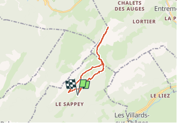
Trail Walking of 12.5 km to be discovered at Auvergne-Rhône-Alpes, Upper Savoy, Thônes. This trail is proposed by Chabard.
Description
Depuis le parking du Crêt.
Positioning
Country:
France
Region :
Auvergne-Rhône-Alpes
Department/Province :
Upper Savoy
Municipality :
Thônes
Location:
Unknown
Start:(Dec)
Start:(UTM)
292452 ; 5088244 (32T) N.
Comments