


entre cesson et rennes

annierrd
User
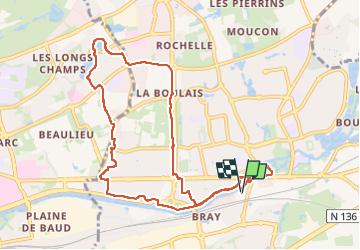

Length
10.2 km

Max alt
66 m

Uphill gradient
84 m
Km-Effort
11.3 km

Min alt
22 m

Downhill gradient
83 m
Boucle
Yes
Creation date :
2025-05-25 11:43:43.016
Updated on :
2025-05-25 14:37:11.068
2h53
Difficulty : Medium

FREE GPS app for hiking
 SityTrail
IGN / Geographical institutes
SityTrail Plus
The world is yours!
About
Trail Walking of 10.2 km to be discovered at Brittany, Ille-et-Vilaine, Cesson-Sévigné. This trail is proposed by annierrd.
Photos


Positioning
Country:
France
Region :
Brittany
Department/Province :
Ille-et-Vilaine
Municipality :
Cesson-Sévigné
Location:
Unknown
Start:(Dec)
Start:(UTM)
603517 ; 5329739 (30U) N.
Comments