


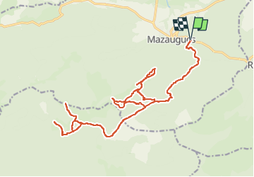
le Mourre d'Agnis/Mazaugues

bernir
User

Length
32 km

Max alt
911 m

Uphill gradient
914 m
Km-Effort
44 km

Min alt
498 m

Downhill gradient
914 m
Boucle
Yes
Creation date :
2025-05-25 08:38:21.366
Updated on :
2025-05-27 06:40:44.886
3h03
Difficulty : Easy

FREE GPS app for hiking
 SityTrail
IGN / Geographical institutes
SityTrail Plus
The world is yours!
About
Trail Mountain bike of 32 km to be discovered at Provence-Alpes-Côte d'Azur, Var, Mazaugues. This trail is proposed by bernir.
Positioning
Country:
France
Region :
Provence-Alpes-Côte d'Azur
Department/Province :
Var
Municipality :
Mazaugues
Location:
Unknown
Start:(Dec)
Start:(UTM)
737567 ; 4803516 (31T) N.
Comments