


MISON . PARCOURS ORIENTATION O

RobinMicheline
User GUIDE
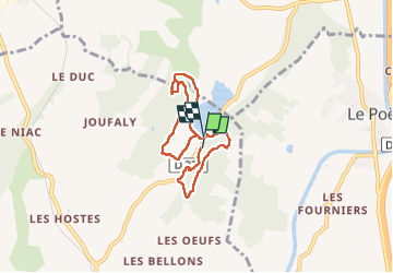

Length
6.6 km

Max alt
730 m

Uphill gradient
178 m
Km-Effort
9 km

Min alt
628 m

Downhill gradient
187 m
Boucle
Yes
Creation date :
2025-05-26 06:17:51.594
Updated on :
2025-07-06 06:36:54.824
2h03
Difficulty : Medium

FREE GPS app for hiking
 SityTrail
IGN / Geographical institutes
SityTrail Plus
The world is yours!
About
Trail Walking of 6.6 km to be discovered at Provence-Alpes-Côte d'Azur, Alpes-de-Haute-Provence, Mison. This trail is proposed by RobinMicheline.
Positioning
Country:
France
Region :
Provence-Alpes-Côte d'Azur
Department/Province :
Alpes-de-Haute-Provence
Municipality :
Mison
Location:
Unknown
Start:(Dec)
Start:(UTM)
729030 ; 4907868 (31T) N.
Comments