


Croix de Jaume GR2

michel38
User
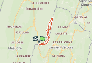

Length
8.8 km

Max alt
1635 m

Uphill gradient
428 m
Km-Effort
14.5 km

Min alt
1224 m

Downhill gradient
423 m
Boucle
Yes
Creation date :
2025-05-26 13:40:37.891
Updated on :
2025-05-26 13:41:07.311
3h17
Difficulty : Difficult

FREE GPS app for hiking
 SityTrail
IGN / Geographical institutes
SityTrail Plus
The world is yours!
About
Trail Walking of 8.8 km to be discovered at Auvergne-Rhône-Alpes, Isère, Lans-en-Vercors. This trail is proposed by michel38.
Positioning
Country:
France
Region :
Auvergne-Rhône-Alpes
Department/Province :
Isère
Municipality :
Lans-en-Vercors
Location:
Unknown
Start:(Dec)
Start:(UTM)
701294 ; 5000625 (31T) N.
Comments