


10km forêt Anlier bis

ThomasW
User
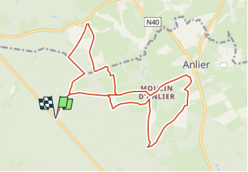

Length
10.4 km

Max alt
470 m

Uphill gradient
237 m
Km-Effort
13.6 km

Min alt
399 m

Downhill gradient
237 m
Boucle
Yes
Creation date :
2025-05-26 15:36:46.724
Updated on :
2025-05-26 15:44:49.113
3h05
Difficulty : Difficult

FREE GPS app for hiking
 SityTrail
IGN / Geographical institutes
SityTrail Plus
The world is yours!
About
Trail Walking of 10.4 km to be discovered at Wallonia, Luxembourg, Habay. This trail is proposed by ThomasW.
Positioning
Country:
Belgium
Region :
Wallonia
Department/Province :
Luxembourg
Municipality :
Habay
Location:
Rulles
Start:(Dec)
Start:(UTM)
686279 ; 5515604 (31U) N.
Comments