


vallée de l'oule

echaneac
User
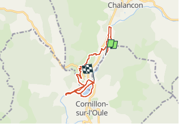

Length
7.3 km

Max alt
613 m

Uphill gradient
137 m
Km-Effort
9.1 km

Min alt
511 m

Downhill gradient
143 m
Boucle
No
Creation date :
2025-05-26 11:50:56.082
Updated on :
2025-05-27 15:22:30.31
2h29
Difficulty : Medium

FREE GPS app for hiking
 SityTrail
IGN / Geographical institutes
SityTrail Plus
The world is yours!
About
Trail Walking of 7.3 km to be discovered at Auvergne-Rhône-Alpes, Drôme, Cornillon-sur-l'Oule. This trail is proposed by echaneac.
Positioning
Country:
France
Region :
Auvergne-Rhône-Alpes
Department/Province :
Drôme
Municipality :
Cornillon-sur-l'Oule
Location:
Unknown
Start:(Dec)
Start:(UTM)
688708 ; 4927015 (31T) N.
Comments