


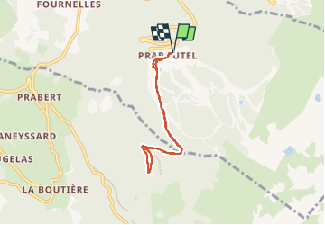
BALADE ENTRE PRAPOUTEL ET LE PRE DE L'ARC

walrou63
User

Length
6 km

Max alt
1451 m

Uphill gradient
161 m
Km-Effort
8.1 km

Min alt
1319 m

Downhill gradient
162 m
Boucle
Yes
Creation date :
2025-05-27 13:56:58.014
Updated on :
2025-05-27 18:12:32.131
1h50
Difficulty : Medium

FREE GPS app for hiking
 SityTrail
IGN / Geographical institutes
SityTrail Plus
The world is yours!
About
Trail Walking of 6 km to be discovered at Auvergne-Rhône-Alpes, Isère, Les Adrets. This trail is proposed by walrou63.
Photos


Positioning
Country:
France
Region :
Auvergne-Rhône-Alpes
Department/Province :
Isère
Municipality :
Les Adrets
Location:
Unknown
Start:(Dec)
Start:(UTM)
735125 ; 5015882 (31T) N.
Comments