


2025-05-28_13h16m59_gpx-trace

poussingilbert
User
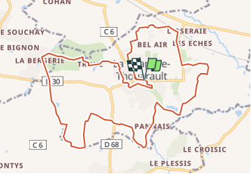

Length
12.8 km

Max alt
63 m

Uphill gradient
97 m
Km-Effort
14 km

Min alt
29 m

Downhill gradient
97 m
Boucle
Yes
Creation date :
2025-05-28 11:16:59.805
Updated on :
2025-05-28 11:17:01.368

FREE GPS app for hiking
 SityTrail
IGN / Geographical institutes
SityTrail Plus
The world is yours!
About
Trail of 12.8 km to be discovered at Brittany, Ille-et-Vilaine, La Chapelle-Thouarault. This trail is proposed by poussingilbert.
Positioning
Country:
France
Region :
Brittany
Department/Province :
Ille-et-Vilaine
Municipality :
La Chapelle-Thouarault
Location:
Unknown
Start:(Dec)
Start:(UTM)
584566 ; 5330600 (30U) N.
Comments