


la montagne d'oule jae

echaneac
User
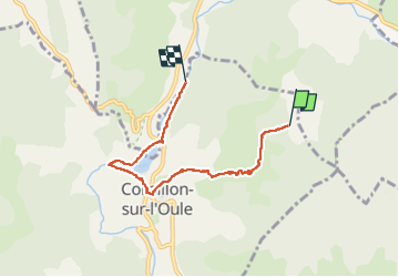

Length
5.2 km

Max alt
963 m

Uphill gradient
20 m
Km-Effort
7 km

Min alt
511 m

Downhill gradient
453 m
Boucle
No
Creation date :
2025-05-28 09:27:57.882
Updated on :
2025-05-28 11:57:12.959
2h28
Difficulty : Medium

FREE GPS app for hiking
 SityTrail
IGN / Geographical institutes
SityTrail Plus
The world is yours!
About
Trail Walking of 5.2 km to be discovered at Auvergne-Rhône-Alpes, Drôme, Cornillon-sur-l'Oule. This trail is proposed by echaneac.

Positioning
Country:
France
Region :
Auvergne-Rhône-Alpes
Department/Province :
Drôme
Municipality :
Cornillon-sur-l'Oule
Location:
Unknown
Start:(Dec)
Start:(UTM)
689986 ; 4926484 (31T) N.
Comments