


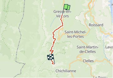
Gresse en Vercors/La Richardière

levequejef
User

Length
15.3 km

Max alt
1726 m

Uphill gradient
816 m
Km-Effort
27 km

Min alt
1039 m

Downhill gradient
983 m
Boucle
No
Creation date :
2025-05-28 07:59:53.681
Updated on :
2025-05-28 14:59:57.725
6h17
Difficulty : Medium

FREE GPS app for hiking
 SityTrail
IGN / Geographical institutes
SityTrail Plus
The world is yours!
About
Trail Walking of 15.3 km to be discovered at Auvergne-Rhône-Alpes, Isère, Gresse-en-Vercors. This trail is proposed by levequejef.
Positioning
Country:
France
Region :
Auvergne-Rhône-Alpes
Department/Province :
Isère
Municipality :
Gresse-en-Vercors
Location:
Unknown
Start:(Dec)
Start:(UTM)
702621 ; 4975151 (31T) N.
Comments