


Dévoluy Lus, col des aiguilles, cascade de Saute Auré, Lachaup

Mariolebeno
User
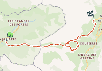

Length
16.1 km

Max alt
2023 m

Uphill gradient
1086 m
Km-Effort
30 km

Min alt
1179 m

Downhill gradient
872 m
Boucle
No
Creation date :
2025-05-29 06:50:07.637
Updated on :
2025-05-29 16:11:32.976
5h15
Difficulty : Difficult

FREE GPS app for hiking
 SityTrail
IGN / Geographical institutes
SityTrail Plus
The world is yours!
About
Trail Walking of 16.1 km to be discovered at Auvergne-Rhône-Alpes, Drôme, Lus-la-Croix-Haute. This trail is proposed by Mariolebeno.
Positioning
Country:
France
Region :
Auvergne-Rhône-Alpes
Department/Province :
Drôme
Municipality :
Lus-la-Croix-Haute
Location:
Unknown
Start:(Dec)
Start:(UTM)
718569 ; 4950444 (31T) N.
Comments