


Villiers-Louis 250529

Specialized77
User GUIDE
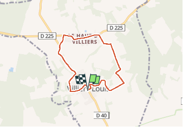

Length
6.4 km

Max alt
213 m

Uphill gradient
118 m
Km-Effort
7.9 km

Min alt
125 m

Downhill gradient
119 m
Boucle
Yes
Creation date :
2025-05-29 13:09:54.957
Updated on :
2025-05-30 06:51:06.081
2h08
Difficulty : Easy

FREE GPS app for hiking
 SityTrail
IGN / Geographical institutes
SityTrail Plus
The world is yours!
About
Trail Walking of 6.4 km to be discovered at Bourgogne-Franche-Comté, Yonne, Villiers-Louis. This trail is proposed by Specialized77.
Description
= 1ère partie du parcours réalisé le 27 avril 2025
Positioning
Country:
France
Region :
Bourgogne-Franche-Comté
Department/Province :
Yonne
Municipality :
Villiers-Louis
Location:
Unknown
Start:(Dec)
Start:(UTM)
529886 ; 5337535 (31U) N.
Comments