


Romans Peyrins

meillon
User
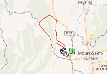

Length
6.1 km

Max alt
291 m

Uphill gradient
126 m
Km-Effort
7.8 km

Min alt
174 m

Downhill gradient
128 m
Boucle
Yes
Creation date :
2025-05-29 14:24:41.387
Updated on :
2025-05-29 16:24:17.024
1h59
Difficulty : Easy

FREE GPS app for hiking
 SityTrail
IGN / Geographical institutes
SityTrail Plus
The world is yours!
About
Trail Walking of 6.1 km to be discovered at Auvergne-Rhône-Alpes, Drôme, Peyrins. This trail is proposed by meillon.
Description
les etangs de Chalere
Positioning
Country:
France
Region :
Auvergne-Rhône-Alpes
Department/Province :
Drôme
Municipality :
Peyrins
Location:
Unknown
Start:(Dec)
Start:(UTM)
660436 ; 4992671 (31T) N.
Comments