


Mille Etangs

michelrenaud
User

Length
5.9 km

Max alt
610 m

Uphill gradient
95 m
Km-Effort
7 km

Min alt
550 m

Downhill gradient
63 m
Boucle
No
Creation date :
2025-05-29 14:14:49.015
Updated on :
2025-05-29 16:48:11.435
2h32
Difficulty : Medium

FREE GPS app for hiking
 SityTrail
IGN / Geographical institutes
SityTrail Plus
The world is yours!
About
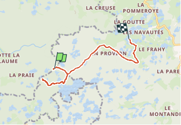
Trail Walking of 5.9 km to be discovered at Bourgogne-Franche-Comté, Haute-Saône, Esmoulières. This trail is proposed by michelrenaud.
Description
randonnée à l étang D'Arfin
Positioning
Country:
France
Region :
Bourgogne-Franche-Comté
Department/Province :
Haute-Saône
Municipality :
Esmoulières
Location:
Unknown
Start:(Dec)
Start:(UTM)
322474 ; 5300079 (32T) N.
Comments