


Clapiers Running

ARVIEU
User
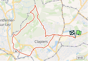

Length
12 km

Max alt
127 m

Uphill gradient
187 m
Km-Effort
14.5 km

Min alt
33 m

Downhill gradient
187 m
Boucle
Yes
Creation date :
2025-05-30 05:50:32.541
Updated on :
2025-05-30 05:52:19.194
1h00
Difficulty : Easy

FREE GPS app for hiking
 SityTrail
IGN / Geographical institutes
SityTrail Plus
The world is yours!
About
Trail Running of 12 km to be discovered at Occitania, Hérault, Jacou. This trail is proposed by ARVIEU.
Positioning
Country:
France
Region :
Occitania
Department/Province :
Hérault
Municipality :
Jacou
Location:
Unknown
Start:(Dec)
Start:(UTM)
573460 ; 4834337 (31T) N.
Comments