


Awenne

BrigitteBertrand
User
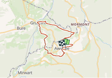

Length
12.9 km

Max alt
425 m

Uphill gradient
390 m
Km-Effort
18 km

Min alt
224 m

Downhill gradient
372 m
Boucle
No
Creation date :
2025-05-30 07:02:28.0
Updated on :
2025-06-01 07:06:58.154
3h41
Difficulty : Difficult

FREE GPS app for hiking
 SityTrail
IGN / Geographical institutes
SityTrail Plus
The world is yours!
About
Trail Walking of 12.9 km to be discovered at Wallonia, Luxembourg, Saint-Hubert. This trail is proposed by BrigitteBertrand.
Description
Ardenne
Photos


Positioning
Country:
Belgium
Region :
Wallonia
Department/Province :
Luxembourg
Municipality :
Saint-Hubert
Location:
Unknown
Start:(Dec)
Start:(UTM)
665035 ; 5549391 (31U) N.
Comments