


champey jeudi

danif
User
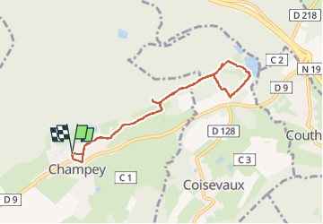

Length
7.7 km

Max alt
400 m

Uphill gradient
131 m
Km-Effort
9.4 km

Min alt
342 m

Downhill gradient
130 m
Boucle
Yes
Creation date :
2025-05-30 10:58:26.979
Updated on :
2025-05-30 13:18:13.127
2h19
Difficulty : Medium

FREE GPS app for hiking
 SityTrail
IGN / Geographical institutes
SityTrail Plus
The world is yours!
About
Trail Walking of 7.7 km to be discovered at Bourgogne-Franche-Comté, Haute-Saône, Champey. This trail is proposed by danif.
Positioning
Country:
France
Region :
Bourgogne-Franche-Comté
Department/Province :
Haute-Saône
Municipality :
Champey
Location:
Unknown
Start:(Dec)
Start:(UTM)
325531 ; 5272957 (32T) N.
Comments