


2025-06-03 marche douce étang minière

Rando MLC
User
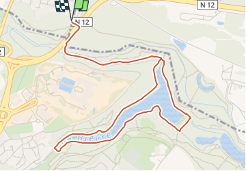

Length
6.4 km

Max alt
167 m

Uphill gradient
69 m
Km-Effort
7.3 km

Min alt
131 m

Downhill gradient
69 m
Boucle
Yes
Creation date :
2025-05-31 14:18:22.393
Updated on :
2025-05-31 14:26:50.101
1h39
Difficulty : Medium

FREE GPS app for hiking
 SityTrail
IGN / Geographical institutes
SityTrail Plus
The world is yours!
About
Trail Walking of 6.4 km to be discovered at Ile-de-France, Yvelines, Saint-Cyr-l'École. This trail is proposed by Rando MLC.
Positioning
Country:
France
Region :
Ile-de-France
Department/Province :
Yvelines
Municipality :
Saint-Cyr-l'École
Location:
Unknown
Start:(Dec)
Start:(UTM)
431747 ; 5404682 (31U) N.
Comments