


monte cassino

Philippr
User
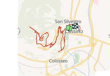

Length
16.6 km

Max alt
522 m

Uphill gradient
606 m
Km-Effort
25 km

Min alt
40 m

Downhill gradient
612 m
Boucle
No
Creation date :
2025-05-31 11:25:02.376
Updated on :
2025-05-31 17:22:04.476
4h11
Difficulty : Very easy

FREE GPS app for hiking
 SityTrail
IGN / Geographical institutes
SityTrail Plus
The world is yours!
About
Trail Walking of 16.6 km to be discovered at Lazio, Frosinone, Cassino. This trail is proposed by Philippr.
Positioning
Country:
Italy
Region :
Lazio
Department/Province :
Frosinone
Municipality :
Cassino
Location:
Unknown
Start:(Dec)
Start:(UTM)
401948 ; 4593906 (33T) N.
Comments