


Les Nonières/Les Richardière

levequejef
User
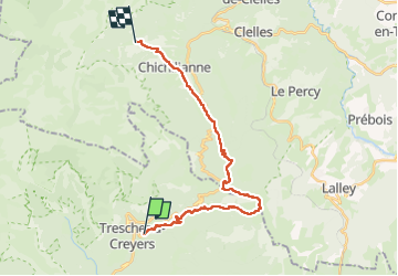

Length
22 km

Max alt
1881 m

Uphill gradient
1316 m
Km-Effort
39 km

Min alt
864 m

Downhill gradient
1146 m
Boucle
No
Creation date :
2025-05-31 07:35:46.388
Updated on :
2025-06-01 07:07:52.522
7h57
Difficulty : Medium

FREE GPS app for hiking
 SityTrail
IGN / Geographical institutes
SityTrail Plus
The world is yours!
About
Trail Walking of 22 km to be discovered at Auvergne-Rhône-Alpes, Drôme, Châtillon-en-Diois. This trail is proposed by levequejef.
Positioning
Country:
France
Region :
Auvergne-Rhône-Alpes
Department/Province :
Drôme
Municipality :
Châtillon-en-Diois
Location:
Treschenu-Creyers
Start:(Dec)
Start:(UTM)
702271 ; 4957048 (31T) N.
Comments