


La baume

nanard223
User

Length
11.1 km

Max alt
938 m

Uphill gradient
210 m
Km-Effort
13.9 km

Min alt
790 m

Downhill gradient
210 m
Boucle
Yes
Creation date :
2025-06-01 06:45:34.0
Updated on :
2025-06-01 09:49:51.699
2h49
Difficulty : Easy

FREE GPS app for hiking
 SityTrail
IGN / Geographical institutes
SityTrail Plus
The world is yours!
About
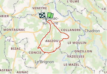
Trail Walking of 11.1 km to be discovered at Auvergne-Rhône-Alpes, Haute-Loire, Solignac-sur-Loire. This trail is proposed by nanard223.
Positioning
Country:
France
Region :
Auvergne-Rhône-Alpes
Department/Province :
Haute-Loire
Municipality :
Solignac-sur-Loire
Location:
Unknown
Start:(Dec)
Start:(UTM)
569580 ; 4979694 (31T) N.
Comments