


Mont Saint Guibert

moere
User
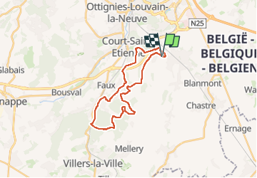

Length
23 km

Max alt
159 m

Uphill gradient
345 m
Km-Effort
27 km

Min alt
64 m

Downhill gradient
345 m
Boucle
Yes
Creation date :
2025-06-01 08:00:31.0
Updated on :
2025-06-01 10:18:21.762

FREE GPS app for hiking
 SityTrail
IGN / Geographical institutes
SityTrail Plus
The world is yours!
About
Trail of 23 km to be discovered at Wallonia, Walloon Brabant, Mont-Saint-Guibert. This trail is proposed by moere.
Positioning
Country:
Belgium
Region :
Wallonia
Department/Province :
Walloon Brabant
Municipality :
Mont-Saint-Guibert
Location:
Mont-Saint-Guibert
Start:(Dec)
Start:(UTM)
613231 ; 5610839 (31U) N.
Comments