


La queriere, longuenoue, moutonnerie, grds fossés

Anastasia Gasnot
User
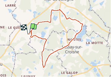

Length
17 km

Max alt
118 m

Uphill gradient
134 m
Km-Effort
18.8 km

Min alt
88 m

Downhill gradient
135 m
Boucle
Yes
Creation date :
2025-06-01 08:34:30.0
Updated on :
2025-06-01 11:11:43.386

FREE GPS app for hiking
 SityTrail
IGN / Geographical institutes
SityTrail Plus
The world is yours!
About
Trail of 17 km to be discovered at Centre-Loire Valley, Loir-et-Cher, Mur-de-Sologne. This trail is proposed by Anastasia Gasnot.
Positioning
Country:
France
Region :
Centre-Loire Valley
Department/Province :
Loir-et-Cher
Municipality :
Mur-de-Sologne
Location:
Unknown
Start:(Dec)
Start:(UTM)
392493 ; 5249049 (31T) N.
Comments