


Étape 4 juin 25

Pascal Bernaud
User

Length
21 km

Max alt
460 m

Uphill gradient
480 m
Km-Effort
27 km

Min alt
230 m

Downhill gradient
489 m
Boucle
No
Creation date :
2025-06-01 05:59:23.0
Updated on :
2025-06-01 13:33:14.035
6h58
Difficulty : Very difficult

FREE GPS app for hiking
 SityTrail
IGN / Geographical institutes
SityTrail Plus
The world is yours!
About
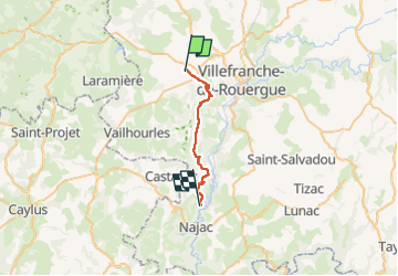
Trail Walking of 21 km to be discovered at Occitania, Aveyron, Savignac. This trail is proposed by Pascal Bernaud.
Positioning
Country:
France
Region :
Occitania
Department/Province :
Aveyron
Municipality :
Savignac
Location:
Unknown
Start:(Dec)
Start:(UTM)
417690 ; 4912360 (31T) N.
Comments