


Sommet du Crémon

Clo0413
User
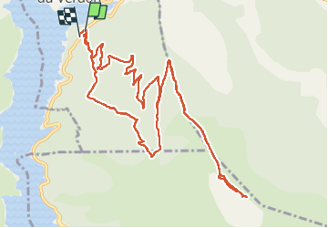

Length
15.5 km

Max alt
1753 m

Uphill gradient
862 m
Km-Effort
27 km

Min alt
925 m

Downhill gradient
878 m
Boucle
Yes
Creation date :
2025-06-01 06:40:57.465
Updated on :
2025-06-02 08:37:17.369
6h08
Difficulty : Very difficult

FREE GPS app for hiking
 SityTrail
IGN / Geographical institutes
SityTrail Plus
The world is yours!
About
Trail Walking of 15.5 km to be discovered at Provence-Alpes-Côte d'Azur, Alpes-de-Haute-Provence, Saint-Julien-du-Verdon. This trail is proposed by Clo0413.
Positioning
Country:
France
Region :
Provence-Alpes-Côte d'Azur
Department/Province :
Alpes-de-Haute-Provence
Municipality :
Saint-Julien-du-Verdon
Location:
Unknown
Start:(Dec)
Start:(UTM)
302894 ; 4864653 (32T) N.
Comments