


Ancy HS 3 juin 25

bstebe
User
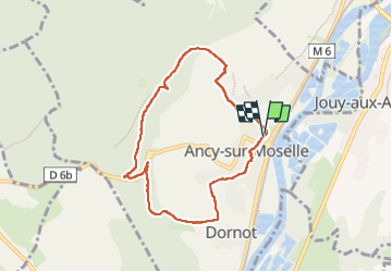

Length
7 km

Max alt
357 m

Uphill gradient
208 m
Km-Effort
9.8 km

Min alt
168 m

Downhill gradient
207 m
Boucle
Yes
Creation date :
2025-06-03 11:45:54.145
Updated on :
2025-06-03 14:59:09.499
3h12
Difficulty : Medium

FREE GPS app for hiking
 SityTrail
IGN / Geographical institutes
SityTrail Plus
The world is yours!
About
Trail Walking of 7 km to be discovered at Grand Est, Moselle, Ancy-Dornot. This trail is proposed by bstebe.
Positioning
Country:
France
Region :
Grand Est
Department/Province :
Moselle
Municipality :
Ancy-Dornot
Location:
Unknown
Start:(Dec)
Start:(UTM)
285315 ; 5438063 (32U) N.
Comments