


PETITE BALADE A PIPAY

walrou63
User
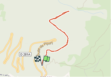

Length
4.3 km

Max alt
1621 m

Uphill gradient
154 m
Km-Effort
6.4 km

Min alt
1491 m

Downhill gradient
151 m
Boucle
Yes
Creation date :
2025-06-03 14:31:05.613
Updated on :
2025-06-04 08:26:43.12
1h15
Difficulty : Medium

FREE GPS app for hiking
 SityTrail
IGN / Geographical institutes
SityTrail Plus
The world is yours!
About
Trail Walking of 4.3 km to be discovered at Auvergne-Rhône-Alpes, Isère, Theys. This trail is proposed by walrou63.
Photos


Positioning
Country:
France
Region :
Auvergne-Rhône-Alpes
Department/Province :
Isère
Municipality :
Theys
Location:
Unknown
Start:(Dec)
Start:(UTM)
265799 ; 5016990 (32T) N.
Comments