


Evian

JLBragard
User

Length
8 km

Max alt
765 m

Uphill gradient
334 m
Km-Effort
12.5 km

Min alt
520 m

Downhill gradient
332 m
Boucle
Yes
Creation date :
2025-06-04 09:31:40.941
Updated on :
2025-06-04 12:08:45.857
2h03
Difficulty : Difficult

FREE GPS app for hiking
 SityTrail
IGN / Geographical institutes
SityTrail Plus
The world is yours!
About
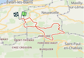
Trail Walking of 8 km to be discovered at Auvergne-Rhône-Alpes, Upper Savoy, Évian-les-Bains. This trail is proposed by JLBragard.
Positioning
Country:
France
Region :
Auvergne-Rhône-Alpes
Department/Province :
Upper Savoy
Municipality :
Évian-les-Bains
Location:
Unknown
Start:(Dec)
Start:(UTM)
314784 ; 5140445 (32T) N.
Comments