Trail Walking Corte - Rando Corte Tavignano - Photo

Rando Corte Tavignano

 Fab-Oz
Fab-Oz

User

© OpenStreetMap contributors
Length
Length
19.6 km
Max alt
Max alt
1040 m
Uphill gradient
Uphill gradient
827 m
Km-Effort
Km-Effort  
31 km
Min alt
Min alt
417 m
Downhill gradient
Downhill gradient
827 m
Boucle
Boucle
Yes
Creation date :
2025-06-04 09:02:26.427
Updated on :
2025-06-04 16:14:31.106

(0 Reviews)

Walking
Walking
6h26
Difficulty : Difficult

Scan this QR Code to open this trail in the SityTrail application

FREE GPS app for hiking

Logo SityTrail SityTrail

IGN / Geographical institutes

Download SityTrail from the App Store Download SityTrail from Google Play

Logo SityTrail SityTrail Plus

The world is yours!

Download SityTrail from the App Store Download SityTrail from Google Play Download SityTrail on Huawei AppGallery

About

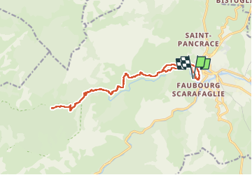
Trail Walking of 19.6 km to be discovered at Corsica, Haute-Corse, Corte. This trail is proposed by Fab-Oz.

Description

Au départ du camping Chez Bartho, on longe le cours d'eau Tavignano. Puis on remonte pour rejoindre le sentier de Mara a Mare Nord, jusqu'au Ponte di u Russulinu, endroit parfait pour une bonne baignade rafraîchissante.
Ensuite, on continue le sentier jusqu'au ravin de Brusco pour de magnifiques points de vue.
Retour par le même sentier, en finissant par la Citadelle de Corte

Elevation profile

Positioning

Country:
France
Region :
Corsica
Department/Province :
Haute-Corse
Municipality :
Corte
Location:
Unknown
Start:(UTM)
512031 ; 4683579 (32T) N.


Close
My subscriptions