


Prapic - Saut du Laire

ARPF
User
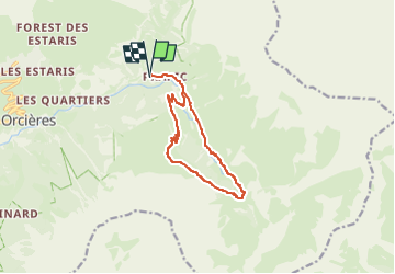

Length
11.6 km

Max alt
2069 m

Uphill gradient
571 m
Km-Effort
19.2 km

Min alt
1523 m

Downhill gradient
567 m
Boucle
Yes
Creation date :
2025-06-04 16:15:15.187
Updated on :
2025-06-04 16:16:57.995
4h22
Difficulty : Difficult

FREE GPS app for hiking
 SityTrail
IGN / Geographical institutes
SityTrail Plus
The world is yours!
About
Trail Walking of 11.6 km to be discovered at Provence-Alpes-Côte d'Azur, Hautes-Alpes, Orcières. This trail is proposed by ARPF.


Positioning
Country:
France
Region :
Provence-Alpes-Côte d'Azur
Department/Province :
Hautes-Alpes
Municipality :
Orcières
Location:
Unknown
Start:(Dec)
Start:(UTM)
291219 ; 4952228 (32T) N.
Comments