


bel air etoile 2 madeleine

ophness
User
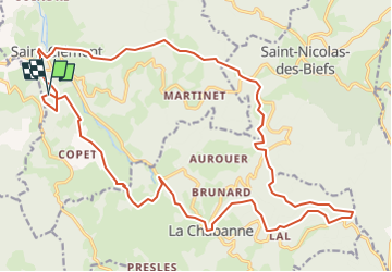

Length
26 km

Max alt
923 m

Uphill gradient
1032 m
Km-Effort
39 km

Min alt
486 m

Downhill gradient
1037 m
Boucle
Yes
Creation date :
2025-06-05 10:09:10.562
Updated on :
2025-06-05 10:09:28.91
5h11
Difficulty : Difficult

FREE GPS app for hiking
 SityTrail
IGN / Geographical institutes
SityTrail Plus
The world is yours!
About
Trail Horseback riding of 26 km to be discovered at Auvergne-Rhône-Alpes, Allier, Saint-Clément. This trail is proposed by ophness.
Positioning
Country:
France
Region :
Auvergne-Rhône-Alpes
Department/Province :
Allier
Municipality :
Saint-Clément
Location:
Unknown
Start:(Dec)
Start:(UTM)
554337 ; 5100065 (31T) N.
Comments