


Paros / Mont Chabrio

tyntyn
User
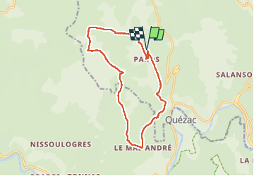

Length
14.8 km

Max alt
1094 m

Uphill gradient
466 m
Km-Effort
21 km

Min alt
671 m

Downhill gradient
466 m
Boucle
Yes
Creation date :
2025-06-05 12:02:46.243
Updated on :
2025-06-05 16:15:17.844
4h11
Difficulty : Very difficult

FREE GPS app for hiking
 SityTrail
IGN / Geographical institutes
SityTrail Plus
The world is yours!
About
Trail Walking of 14.8 km to be discovered at Occitania, Lozère, Ispagnac. This trail is proposed by tyntyn.
Photos


Positioning
Country:
France
Region :
Occitania
Department/Province :
Lozère
Municipality :
Ispagnac
Location:
Unknown
Start:(Dec)
Start:(UTM)
540458 ; 4915935 (31T) N.
Comments