


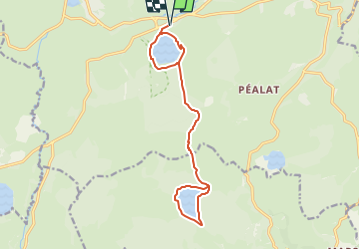
Lac Pavin/ lac de Montcineyre

geoffrayLayeux
User

Length
15.1 km

Max alt
1311 m

Uphill gradient
354 m
Km-Effort
19.8 km

Min alt
1168 m

Downhill gradient
354 m
Boucle
Yes
Creation date :
2025-06-05 18:18:17.43
Updated on :
2025-06-05 18:19:11.731
4h30
Difficulty : Very difficult

FREE GPS app for hiking
 SityTrail
IGN / Geographical institutes
SityTrail Plus
The world is yours!
About
Trail Walking of 15.1 km to be discovered at Auvergne-Rhône-Alpes, Puy-de-Dôme, Besse-et-Saint-Anastaise. This trail is proposed by geoffrayLayeux.
Positioning
Country:
France
Region :
Auvergne-Rhône-Alpes
Department/Province :
Puy-de-Dôme
Municipality :
Besse-et-Saint-Anastaise
Location:
Besse
Start:(Dec)
Start:(UTM)
491380 ; 5038700 (31T) N.
Comments