


Valleraugue AR

ARVIEU
User
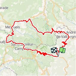

Length
109 km

Max alt
1311 m

Uphill gradient
2665 m
Km-Effort
145 km

Min alt
353 m

Downhill gradient
2665 m
Boucle
Yes
Creation date :
2015-07-25 00:00:00.0
Updated on :
2015-07-25 00:00:00.0
8h11
Difficulty : Medium

FREE GPS app for hiking
 SityTrail
IGN / Geographical institutes
SityTrail Plus
The world is yours!
About
Trail Cycle of 109 km to be discovered at Occitania, Gard, Val-d'Aigoual. This trail is proposed by ARVIEU.
Description
Vallerauge
Positioning
Country:
France
Region :
Occitania
Department/Province :
Gard
Municipality :
Val-d'Aigoual
Location:
Valleraugue
Start:(Dec)
Start:(UTM)
551461 ; 4881048 (31T) N.
Comments