


Les rousses

sameja
User
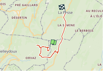

Length
10.7 km

Max alt
1251 m

Uphill gradient
323 m
Km-Effort
15.2 km

Min alt
1029 m

Downhill gradient
377 m
Boucle
No
Creation date :
2025-06-06 08:55:52.0
Updated on :
2025-06-06 14:26:51.439
5h25
Difficulty : Medium

FREE GPS app for hiking
 SityTrail
IGN / Geographical institutes
SityTrail Plus
The world is yours!
About
Trail Walking of 10.7 km to be discovered at Auvergne-Rhône-Alpes, Ain, Belleydoux. This trail is proposed by sameja.
Description
UF1
Positioning
Country:
France
Region :
Auvergne-Rhône-Alpes
Department/Province :
Ain
Municipality :
Belleydoux
Location:
Unknown
Start:(Dec)
Start:(UTM)
717997 ; 5126249 (31T) N.
Comments