


Le Puy de Sancy

Bcomb
User
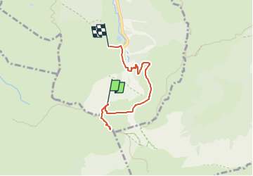

Length
4.9 km

Max alt
1860 m

Uphill gradient
97 m
Km-Effort
7.6 km

Min alt
1320 m

Downhill gradient
537 m
Boucle
No
Creation date :
2025-06-07 08:22:18.468
Updated on :
2025-06-07 08:59:28.497
1h43
Difficulty : Easy

FREE GPS app for hiking
 SityTrail
IGN / Geographical institutes
SityTrail Plus
The world is yours!
About
Trail On foot of 4.9 km to be discovered at Auvergne-Rhône-Alpes, Puy-de-Dôme, Mont-Dore. This trail is proposed by Bcomb.
Positioning
Country:
France
Region :
Auvergne-Rhône-Alpes
Department/Province :
Puy-de-Dôme
Municipality :
Mont-Dore
Location:
Unknown
Start:(Dec)
Start:(UTM)
485415 ; 5042142 (31T) N.
Comments