


Sarreguemines (57) 250607

Specialized77
User GUIDE
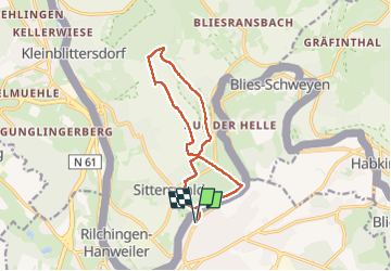

Length
11.8 km

Max alt
354 m

Uphill gradient
219 m
Km-Effort
14.7 km

Min alt
194 m

Downhill gradient
219 m
Boucle
Yes
Creation date :
2025-06-07 11:38:03.583
Updated on :
2025-06-07 15:02:40.383
3h11
Difficulty : Easy

FREE GPS app for hiking
 SityTrail
IGN / Geographical institutes
SityTrail Plus
The world is yours!
About
Trail Walking of 11.8 km to be discovered at Grand Est, Moselle, Sarreguemines. This trail is proposed by Specialized77.
Positioning
Country:
France
Region :
Grand Est
Department/Province :
Moselle
Municipality :
Sarreguemines
Location:
Unknown
Start:(Dec)
Start:(UTM)
359494 ; 5442954 (32U) N.
Comments