


Vaucluse Crestet

Superpape
User
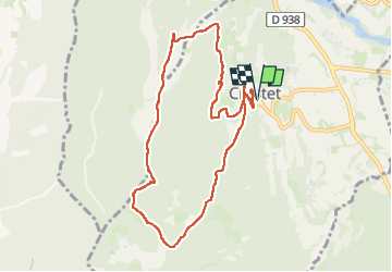

Length
10.2 km

Max alt
502 m

Uphill gradient
265 m
Km-Effort
13.8 km

Min alt
310 m

Downhill gradient
267 m
Boucle
Yes
Creation date :
2025-06-07 13:57:18.391
Updated on :
2025-07-23 19:30:39.782
2h32
Difficulty : Difficult

FREE GPS app for hiking
 SityTrail
IGN / Geographical institutes
SityTrail Plus
The world is yours!
About
Trail Walking of 10.2 km to be discovered at Provence-Alpes-Côte d'Azur, Vaucluse, Crestet. This trail is proposed by Superpape.
Positioning
Country:
France
Region :
Provence-Alpes-Côte d'Azur
Department/Province :
Vaucluse
Municipality :
Crestet
Location:
Unknown
Start:(Dec)
Start:(UTM)
666603 ; 4897894 (31T) N.
Comments