


maurettes
© OpenStreetMap contributors


3h12
Difficulty : Medium


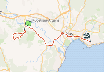
Length
28 km
Max alt
243 m
Uphill gradient
423 m
Km-Effort
34 km
Min alt
1 m
Downhill gradient
437 m
Boucle
No
Creation date :
2025-06-08 06:31:16.86
Updated on :
2025-06-08 11:14:37.125
3h12
Difficulty : Medium
FREE GPS app for hiking
 SityTrail
IGN / Geographical institutes
SityTrail Plus
The world is yours!
About
Trail Walking of 28 km to be discovered at Provence-Alpes-Côte d'Azur, Var, Roquebrune-sur-Argens. This trail is proposed by jack.cavelier@orange.fr.
Positioning
Country:
France
Region :
Provence-Alpes-Côte d'Azur
Department/Province :
Var
Municipality :
Roquebrune-sur-Argens
Location:
Unknown
Start:(Dec)
Start:(UTM)
308506 ; 4812389 (32T) N.
Comments