


Buzenol 2025

iznogud
User
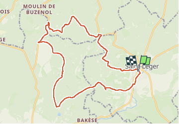

Length
19.8 km

Max alt
353 m

Uphill gradient
433 m
Km-Effort
26 km

Min alt
228 m

Downhill gradient
430 m
Boucle
Yes
Creation date :
2025-06-08 07:40:14.0
Updated on :
2025-06-08 11:38:13.093

FREE GPS app for hiking
 SityTrail
IGN / Geographical institutes
SityTrail Plus
The world is yours!
About
Trail of 19.8 km to be discovered at Wallonia, Luxembourg, Saint-Léger. This trail is proposed by iznogud.
Positioning
Country:
Belgium
Region :
Wallonia
Department/Province :
Luxembourg
Municipality :
Saint-Léger
Location:
Saint-Léger
Start:(Dec)
Start:(UTM)
691755 ; 5498748 (31U) N.
Comments