


GR_34_FD_39_Morlaix_Taule_20250608

patrickdanilo
User
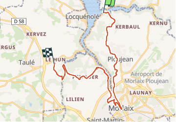

Length
15.3 km

Max alt
90 m

Uphill gradient
313 m
Km-Effort
19.2 km

Min alt
3 m

Downhill gradient
259 m
Boucle
No
Creation date :
2025-06-08 07:04:45.909
Updated on :
2025-06-11 16:45:53.438
4h22
Difficulty : Medium

FREE GPS app for hiking
 SityTrail
IGN / Geographical institutes
SityTrail Plus
The world is yours!
About
Trail Walking of 15.3 km to be discovered at Brittany, Finistère, Morlaix. This trail is proposed by patrickdanilo.
Description
Randonnée Marche de 15,3 km à découvrir à Bretagne, Finistère, Morlaix. Cette randonnée est proposée par patrickdanilo.
Photos


Positioning
Country:
France
Region :
Brittany
Department/Province :
Finistère
Municipality :
Morlaix
Location:
Unknown
Start:(Dec)
Start:(UTM)
437705 ; 5386348 (30U) N.
Comments