


pandour wagenbourg

feelou
User
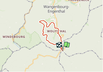

Length
9.5 km

Max alt
823 m

Uphill gradient
366 m
Km-Effort
14.4 km

Min alt
499 m

Downhill gradient
370 m
Boucle
Yes
Creation date :
2025-06-08 13:18:59.914
Updated on :
2025-06-08 15:53:51.941
2h31
Difficulty : Difficult

FREE GPS app for hiking
 SityTrail
IGN / Geographical institutes
SityTrail Plus
The world is yours!
About
Trail Walking of 9.5 km to be discovered at Grand Est, Bas-Rhin, Cosswiller. This trail is proposed by feelou.
Positioning
Country:
France
Region :
Grand Est
Department/Province :
Bas-Rhin
Municipality :
Cosswiller
Location:
Unknown
Start:(Dec)
Start:(UTM)
375822 ; 5383202 (32U) N.
Comments