


2015 05 22 fiente de los campos

vsellier
User

Length
25 km

Max alt
755 m

Uphill gradient
263 m
Km-Effort
29 km

Min alt
543 m

Downhill gradient
424 m
Boucle
No
Creation date :
2015-07-23 00:00:00.0
Updated on :
2015-07-23 00:00:00.0
7h47
Difficulty : Unknown

FREE GPS app for hiking
 SityTrail
IGN / Geographical institutes
SityTrail Plus
The world is yours!
About
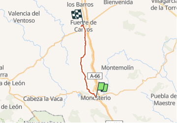
Trail Walking of 25 km to be discovered at Extremadura, Badajoz, Monesterio. This trail is proposed by vsellier.
Positioning
Country:
Spain
Region :
Extremadura
Department/Province :
Badajoz
Municipality :
Monesterio
Location:
Unknown
Start:(Dec)
Start:(UTM)
739252 ; 4218998 (29S) N.
Comments