


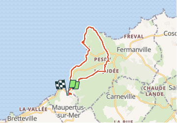
Boucle Cap & Fort Lévy

rigol05
User

Length
11.2 km

Max alt
75 m

Uphill gradient
166 m
Km-Effort
13.4 km

Min alt
0 m

Downhill gradient
166 m
Boucle
Yes
Creation date :
2025-06-09 11:31:48.362
Updated on :
2025-06-25 15:59:00.412
2h55
Difficulty : Medium

FREE GPS app for hiking
 SityTrail
IGN / Geographical institutes
SityTrail Plus
The world is yours!
About
Trail Walking of 11.2 km to be discovered at Normandy, Manche, Maupertus-sur-Mer. This trail is proposed by rigol05.
Description
Séjour Cotentin - 09/06/2025
Positioning
Country:
France
Region :
Normandy
Department/Province :
Manche
Municipality :
Maupertus-sur-Mer
Location:
Unknown
Start:(Dec)
Start:(UTM)
609117 ; 5502600 (30U) N.
Comments