


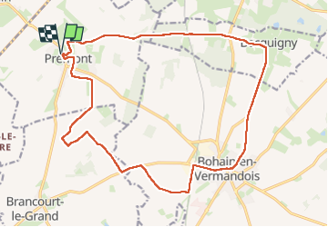
Prémont

jpblimond
User

Length
19.6 km

Max alt
169 m

Uphill gradient
226 m
Km-Effort
23 km

Min alt
123 m

Downhill gradient
225 m
Boucle
Yes
Creation date :
2025-06-09 10:44:26.0
Updated on :
2025-06-09 15:16:34.827
4h31
Difficulty : Medium

FREE GPS app for hiking
 SityTrail
IGN / Geographical institutes
SityTrail Plus
The world is yours!
About
Trail Walking of 19.6 km to be discovered at Hauts-de-France, Aisne, Prémont. This trail is proposed by jpblimond.
Positioning
Country:
France
Region :
Hauts-de-France
Department/Province :
Aisne
Municipality :
Prémont
Location:
Unknown
Start:(Dec)
Start:(UTM)
528113 ; 5540341 (31U) N.
Comments