


9 juin partie 2

PaulNord
User
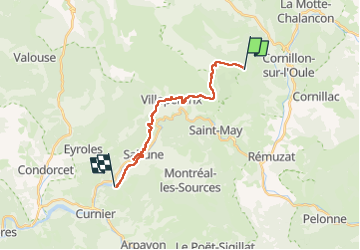

Length
17.7 km

Max alt
1003 m

Uphill gradient
343 m
Km-Effort
24 km

Min alt
337 m

Downhill gradient
1002 m
Boucle
No
Creation date :
2025-06-09 09:13:16.84
Updated on :
2025-06-09 15:44:40.349
6h24
Difficulty : Very difficult

FREE GPS app for hiking
 SityTrail
IGN / Geographical institutes
SityTrail Plus
The world is yours!
About
Trail Walking of 17.7 km to be discovered at Auvergne-Rhône-Alpes, Drôme, Villeperdrix. This trail is proposed by PaulNord.
Positioning
Country:
France
Region :
Auvergne-Rhône-Alpes
Department/Province :
Drôme
Municipality :
Villeperdrix
Location:
Unknown
Start:(Dec)
Start:(UTM)
685930 ; 4925212 (31T) N.
Comments